The curse of cartography: India-China border dispute
Subhranil Ghosh is a Final year Post Graduate student studying at the Department of International Relations in Jadavpur University. He wishes to pursue a career in the academia. His interest areas are political thought and theory.
The recent border dispute between India and the People’s Republic of China is a fallout due to unresolved cartographic tensions and policies that end up putting the two Asian giants on a collision course. A disputed Himalayan Border is often cited as the major cause behind the intermittent clashes between the two powers. It needs to be understood that the process in which the political leadership of a state interprets geography and geographical features has a direct bearing on the kind of political stances it adopts towards the other states involved in the dispute.
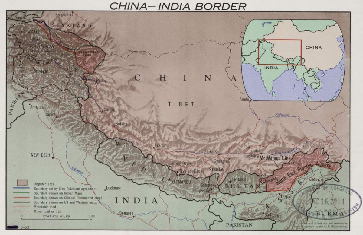
The India China Border is divided into three sectors, the Western, Middle, and Eastern sectors. The boundary dispute in the Western Sector pertains to the Johnson Line proposed by the British in the 1860s that extended up to the Kunlun Mountains. It places Aksai Chin in the then Princely State of Jammu and Kashmir. Independent India subscribed to the Johnson Line, claiming Aksai Chin as part of India. Throughout the 1950s, the Chinese accepted this arrangement. In the middle sector of the Sino Indian Border, both the countries have exchanged maps on which they broadly agree. The disputed boundary in the Eastern sector is over the McMohan Line proposed by the British colonial administrator Sir Henry McMohan which was an official demarcation line between the Tibetan region of China and the North East Region of India at the 1914 Shimla Convention. Geographically, it extends for 550 miles from Bhutan in the west, and about 160 miles eastward from the Great bend of the Brahmaputra river, along the crest of the Himalayas. Independent India had accepted it as the legal International Border while China rejected the McMohan line. China argues that Tibet was not a sovereign state at the time of the Shimla Convention, thereby invalidating the legality of the treaty. Beijing maintains that without the power to conclude treaties, the Simla Accord does not hold ground. According to the British Journalist Neville Maxwell, in his book, “India’s China War,” Mcmohan had been instructed not to sign bilaterally with the Tibetans if the Chinese refused. Nevertheless, Mcmohan went ahead with the signature and kept the declaration secret.
The Mcmohan Line lay at the center of the Sino-Indian border dispute in the 1960s, with Chinese forces launching a full-scale assault across the line in 1962. V.K.Singh argued that the basis of these boundaries was the idea that the Himalayas were the historical boundaries of India. The areas south of the Himalayas were associated with India. Following this line of reasoning, the Indian Government was of the opinion that since the Himalayas were the ancient boundaries of the Indian Subcontinent, they would serve as the modern boundaries of British Indian and later on the Republic of India. Throughout the 1950s, when Sino-Indian relations were cordial, Prime Minister Jawaharlal Nehru maintained that China would come to accept the border as fait accompli. India had acknowledged Tibet to be an integral part of China, giving up extraterritorial rights in Tibet.
In this context, it needs to be mentioned that in the course of the 1950s, the People’s Republic of China set about the construction of a 1200 kilometer long road connecting Xinjiang with Western Tibet, of which 179 kilometers extended southwards from the Johnson Line through the Aksai Chin region claimed by India. When India became aware of such a road after the road was shown in Chinese Maps in 1958, Nehru had unequivocally stated the Indian position regarding Aksai Chin. Nehru said that “part of the Ladakh region” is “ of India for centuries,” adding that this northern border was a “firm and definite one which was not open to be discussed with anybody.” The Chinese Premier Zhou Enlai had argued that British efforts at delineating the Western Border were inconsistent and that the Chinese were only following the Macartney-Macdonald Line, which the Chinese claimed were the only line proposed to them by the British. Adding that since Aksai Chin was already under Chinese jurisdiction, any negotiation would have to take into consideration the status quo. As negotiations failed, the PRC pursued an aggressive course of action, vividly recorded.
The ensuing Sino Indian war resulted in the establishment of a “Line of Actual Control,” which roughly demarcated the Sino-Indian Border from 1962 to 1993 while distinguishing between the territories controlled by India and the PRC. The border dispute, however, remains unresolved to this day. In 1981, there were several rounds of talks, but no agreement was reached on the issue. Several times, incursions along the border have taken place, with each state blaming the other for provocative actions. India has stated that the boundaries proposed by China in Ladakh and Arunachal Pradesh have no written basis and any documentation of acceptance. India further argued that China’s claims are predicated on the idea that the region was under Chinese Imperial control in the past. China has responded by highlighting that Indian attempts to legitimize its claims are based on the fact that the areas were under British Imperial Control. Even when confidence-building measures have been in place since 1993, the recent military standoff between the Asian giants is again drawing widespread attention. Even as the Line of Actual Control has ensured a modicum of stability in Sino-Indian relations, India has had to contend with area denial strategies set by PLA patrolling.
As the last major standoff at Doklam deescalated in 2017, the PRC has increased military presence in the Tibetan Plateau Region, with commentators claiming that the deployment of advanced weapons systems is intended to show India China’s increasingly sophisticated capabilities. Of particular concern for the Indian establishment is the Chinese construction of the Ngari Gunsa airport about 200 kilometers from Panging Tai, in Ladakh. Taylor Gravel has argued that the flashpoint is Indian efforts at infrastructure development in Ladakh, close to the Chinese Line of Actual Control, particularly the Darbur-Shyok-DBO Road, which connects the city of Leh via the villages of Darbuk and Shyok with the Daulat Beg Oldi Post near the China Border. Former Indian Ambassador to China Ashok Kantha argues that Chinese actions should not be viewed as localized incidents but rather as indicative of increasing Chinese assertiveness, especially in the wake of the Covid-19 Pandemic, which inadvertently led to the damaging of China’s economy and its diplomatic relationships worldwide.
While both states held Lt General level talks and a commitment to peacefully resolving the dispute was reaffirmed, the problem lies with the lack of a well-defined border, in the absence of which such confrontations are bound to happen. India has pledged to respond to Chinese tactics of intimidation with a firm resolve, as was evident in Doklam. However, a permanent solution depends upon the degree of statecraft exercised based on mutual interest and understanding. The issue of whether India and China can grow together needs to be dealt with. If a conflict situation is to be avoided, then it is imperative that the governments of the two countries amicably negotiate and come to an agreement over the border. That will be a befitting demonstration of matured and conciliatory diplomatic posturing between two important powers destined to shape the trajectory of the much-vaunted ‘Asian Century.’
Featured Image Credits: Wikimedia


Readers' Reviews (1 reply)